
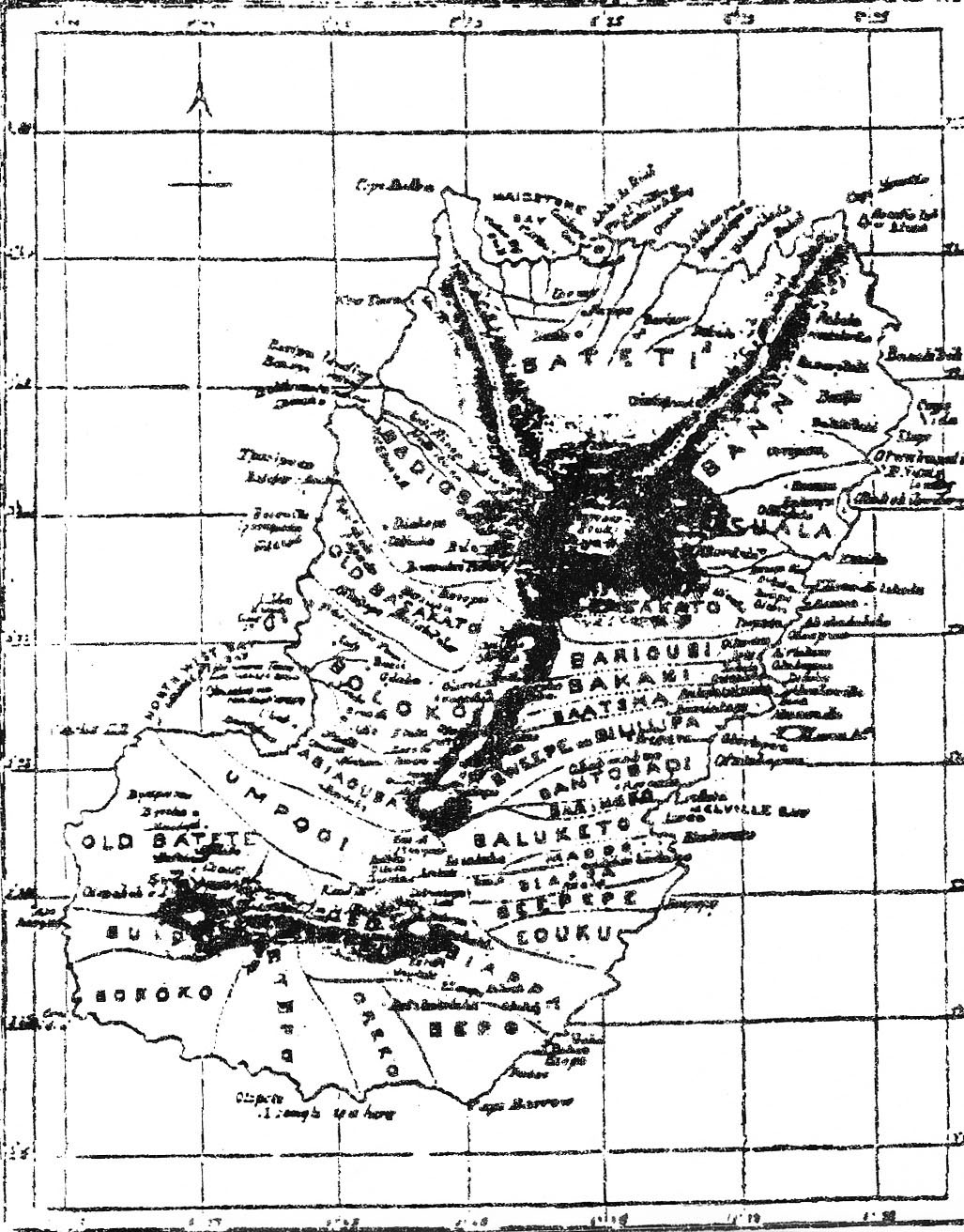
 Map made by British missionary John Clarke showing Bubi tribal locations in the years 1841 to 1846. Printed in the M.H., August 1852. (From Los Bubis on Fernando Poo)
Chapters 5 to 7: Early tribal splits
5. Why There are Two Batetes
The country was incapable of holding and feeding such a large multitude. The old residents took up weapons to defend their property and way of life from these invaders. After a prolonged and bloody war between both villages, the newly arrived Batetes beat the old Batetes and forced them to ask for peace. Peace was conceded, with the condition that the old Batetes leave their homeland and emigrate to a more-distant territory.
Before setting out on their march into exile, they first consulted with the tribal prophet, bojiammó or mohiamorimó, as was the custom before undertaking any important enterprise. The notables congregated to offer a sacrifice of goats in the manner of their ancestors, so that they would know from those ancestors where they should direct their steps. The response from the mohiamorimó was: “Send some men to the forest to hunt a live deer. Attach a bell around its neck and set it free. Then, all the people, with the chiefs in front of their respective families, follow that deer until it stops and, despite your prodding, refuses to take another step. Do not fear,” Mojiammó continued, “because your guardian spirit will accompany you and invisibly direct your steps to the new homeland. There you will be doubly happy and enjoy lasting and unalterable peace and tranquillity.”
The people blindly obeyed the oracle and followed the animal chosen by the guardian spirit to the Promised Land. The hike was relatively long and they walked about a week. They crossed the country of the Babiaoma, Baloketo, and Bazakate, and arriving at the plateau of the Apú River, the deer refused to walk farther. They clearly understood this message from the guardian spirit that they establish themselves there. They complied with humility and gratitude.
6. Baney and Basuala
In 1911, a revered old man of Basupú of the West told me that when the original Batetes came to Basupú, they found that all of the northern part of the island was occupied by the Baney and Basuala. As it was the firm and irrevocable will of the Batete guardian spirit that they live protected once and for all in those regions, that same spirit encouraged them and helped them eject the Baney and Basuala. With very little effort, they forced the old inhabitants to transmigrate farther from the Eputu. The Batetes were then free to distribute themselves in the immense territory between the Eputu and Ope rivers.
Of further note is that the big village of the northern Batetes was divided into subtribes, whose names are the Bahu and Bariobatta. The Bahu are the Rebolanos, Basapos of Rebola, Basilés, and Banapás, who occupy the region between the Eputu and the Boopebilo rivers. The Bariobatta occupy the area containing this last river (Boopebilo) and the Ope, and are the Basupús, Basapos of Basupú, Balveris, and Batoikoppos.
All of the aforementioned was told to me by the mochuku of the vanished village of Riringó of western Boloko in 1897, who came to Musola with his people to help us clear trees around the mission. Much later, I saw him in Basakato of the West and, in 1914, in the village of Baneba of Baney.
The last Batetes, or the southern or modern Batetes, divided themselves in three big groups in numerous settlements. Their boundaries are: in the north, the sea; in the south, the Lopeló mountains; in the east, Balombe and Ruiché of Balacha; and in the west, the Oko river, which separated them from the Bokokos. The names of the villages of the above mentioned are Ríobanda, Ríokoritcho, and Ratcha or Ruitche.
7. Why There are Two Basakatos
We previously noted that the Basakatos established themselves north of the western Baloketos, from the river Rupé to the Ope, at the foot of Santa Isabel mountain. In time they multiplied in such prodigious numbers that their land became too small to contain them. They also encountered another serious obstacle: Their tribe could not expand to either side of the mountain, only up the peak.
Fights broke out over palm trees and available terrain for planting yams, malangas, and other edibles. This antagonism at times led to bloodshed. On one occasion, with a palm tree the cause of a dispute between two individuals, the Basakatos split into two factions. The larger, more powerful of the two defeated the smaller, weaker faction, forcing them to relocate.
In their emigration, they took the road to the north. They begged hospitality from the Batetes of the same region, and from the Baney and Basuala, but no one of them would admit them into their country or offer them even a handful of land. They eventually arrived at a still-uninhabited region, situated between the Basualas and Bariaobes. Going higher and surveying the entire region, they resolved to settle there. Here they formed the four notable populations that compose the region: Rebola de Basakato, Basupú de Basakato, Basinoka, and Barépara, which is reduced at the present time to two populations: Rebola and Basupú, with the generic name of Basakato of the East, and Basinoka and Barépara, with the name of Bososo.
This demonstrates that both Basakatos are one and the same Bubi subtribe. The eastern Basakatos were ejected from western Basakato. The proof is that both people speak the same Bubi dialect, in spite of being so distant and living between people with quite different dialects. This history was told to me in 1914 by those of Basakato of the East, and later by those of Basakato of the West, which assured me it is true.